


2016-05-08 17:12:37

CHEMINS ENCHATAIGNERAIE
Marchons en Chataigneraie
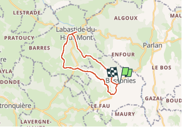

Length
11.5 km

Max alt
783 m

Uphill gradient
282 m
Km-Effort
15.2 km

Min alt
543 m

Downhill gradient
278 m
Boucle
Yes
Creation date :
2021-01-02 13:23:00.291
Updated on :
2025-03-17 14:00:29.42
3h27
Difficulty : Easy

FREE GPS app for hiking
 SityTrail
IGN / Geographical institutes
SityTrail Plus
The world is yours!
About
Trail On foot of 11.5 km to be discovered at Occitania, Lot, Bessonies. This trail is proposed by CHEMINS ENCHATAIGNERAIE.
Positioning
Country:
France
Region :
Occitania
Department/Province :
Lot
Municipality :
Bessonies
Location:
Unknown
Start:(Dec)
Start:(UTM)
432830 ; 4962233 (31T) N.
Comments