


la rando de norroy

nouga
User
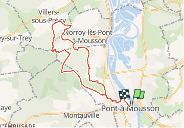

Length
16.7 km

Max alt
383 m

Uphill gradient
378 m
Km-Effort
22 km

Min alt
175 m

Downhill gradient
378 m
Boucle
Yes
Creation date :
2021-01-02 18:20:41.281
Updated on :
2021-01-02 18:23:48.226
1h25
Difficulty : Medium

FREE GPS app for hiking
 SityTrail
IGN / Geographical institutes
SityTrail Plus
The world is yours!
About
Trail Mountain bike of 16.7 km to be discovered at Grand Est, Meurthe-et-Moselle, Pont-à-Mousson. This trail is proposed by nouga.
Positioning
Country:
France
Region :
Grand Est
Department/Province :
Meurthe-et-Moselle
Municipality :
Pont-à-Mousson
Location:
Unknown
Start:(Dec)
Start:(UTM)
284240 ; 5420948 (32U) N.
Comments