


Tour au-dessus de Corconne par le Pont du Hasard et le Chateau

DiagMan
User
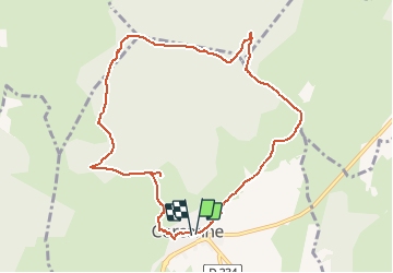

Length
10.2 km

Max alt
340 m

Uphill gradient
302 m
Km-Effort
14.2 km

Min alt
138 m

Downhill gradient
301 m
Boucle
Yes
Creation date :
2021-01-02 18:58:14.564
Updated on :
2021-01-02 19:05:45.032
2h50
Difficulty : Difficult

FREE GPS app for hiking
 SityTrail
IGN / Geographical institutes
SityTrail Plus
The world is yours!
About
Trail Walking of 10.2 km to be discovered at Occitania, Gard, Corconne. This trail is proposed by DiagMan.
Positioning
Country:
France
Region :
Occitania
Department/Province :
Gard
Municipality :
Corconne
Location:
Unknown
Start:(Dec)
Start:(UTM)
575609 ; 4858104 (31T) N.
Comments