


Anhée B

pierlan
User
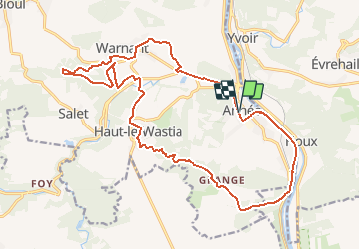

Length
19.8 km

Max alt
235 m

Uphill gradient
489 m
Km-Effort
26 km

Min alt
84 m

Downhill gradient
488 m
Boucle
Yes
Creation date :
2021-01-03 10:20:53.446
Updated on :
2021-01-03 10:46:02.056
--
Difficulty : Very easy

FREE GPS app for hiking
 SityTrail
IGN / Geographical institutes
SityTrail Plus
The world is yours!
About
Trail Trail of 19.8 km to be discovered at Wallonia, Namur, Anhée. This trail is proposed by pierlan.
Positioning
Country:
Belgium
Region :
Wallonia
Department/Province :
Namur
Municipality :
Anhée
Location:
Anhée
Start:(Dec)
Start:(UTM)
633619 ; 5574715 (31U) N.
Comments