


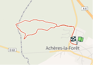
Achères la Forêt chemin de la pente de la garenne

BrassensJC
User

Length
4.6 km

Max alt
122 m

Uphill gradient
59 m
Km-Effort
5.3 km

Min alt
81 m

Downhill gradient
59 m
Boucle
Yes
Creation date :
2014-12-10 00:00:00.0
Updated on :
2014-12-10 00:00:00.0
1h10
Difficulty : Unknown

FREE GPS app for hiking
 SityTrail
IGN / Geographical institutes
SityTrail Plus
The world is yours!
About
Trail Walking of 4.6 km to be discovered at Ile-de-France, Seine-et-Marne, Achères-la-Forêt. This trail is proposed by BrassensJC.
Positioning
Country:
France
Region :
Ile-de-France
Department/Province :
Seine-et-Marne
Municipality :
Achères-la-Forêt
Location:
Unknown
Start:(Dec)
Start:(UTM)
467798 ; 5356200 (31U) N.
Comments
Excellente application
Excellente application