


Charly

Bernardcom
User

Length
9.6 km

Max alt
79 m

Uphill gradient
55 m
Km-Effort
10.4 km

Min alt
53 m

Downhill gradient
55 m
Boucle
Yes
Creation date :
2021-01-04 09:46:59.028
Updated on :
2021-01-04 13:00:16.571
3h12
Difficulty : Very easy

FREE GPS app for hiking
 SityTrail
IGN / Geographical institutes
SityTrail Plus
The world is yours!
About
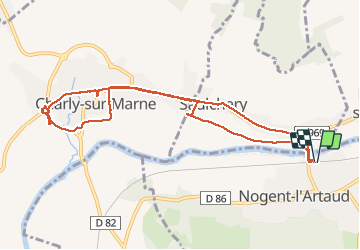
Trail Walking of 9.6 km to be discovered at Hauts-de-France, Aisne, Nogent-l'Artaud. This trail is proposed by Bernardcom.
Positioning
Country:
France
Region :
Hauts-de-France
Department/Province :
Aisne
Municipality :
Nogent-l'Artaud
Location:
Unknown
Start:(Dec)
Start:(UTM)
523596 ; 5424029 (31U) N.
Comments