


atrans

maupassant38
User
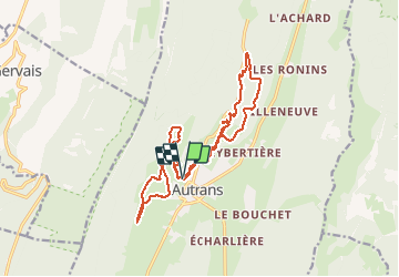

Length
18.5 km

Max alt
1288 m

Uphill gradient
431 m
Km-Effort
24 km

Min alt
1018 m

Downhill gradient
431 m
Boucle
Yes
Creation date :
2021-01-06 10:03:28.285
Updated on :
2021-01-06 14:47:03.621
2h09
Difficulty : Medium

FREE GPS app for hiking
 SityTrail
IGN / Geographical institutes
SityTrail Plus
The world is yours!
About
Trail Cross-country skiing of 18.5 km to be discovered at Auvergne-Rhône-Alpes, Isère, Autrans-Méaudre en Vercors. This trail is proposed by maupassant38.
Positioning
Country:
France
Region :
Auvergne-Rhône-Alpes
Department/Province :
Isère
Municipality :
Autrans-Méaudre en Vercors
Location:
Autrans
Start:(Dec)
Start:(UTM)
699557 ; 5005921 (31T) N.
Comments