


tour forêt Mongeont

Laurent53
User
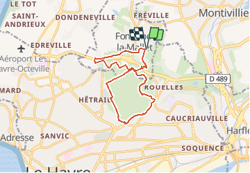

Length
12 km

Max alt
99 m

Uphill gradient
225 m
Km-Effort
15 km

Min alt
21 m

Downhill gradient
225 m
Boucle
Yes
Creation date :
2021-01-07 14:09:55.482
Updated on :
2021-01-07 14:39:52.968
--
Difficulty : Very easy

FREE GPS app for hiking
 SityTrail
IGN / Geographical institutes
SityTrail Plus
The world is yours!
About
Trail On foot of 12 km to be discovered at Normandy, Seine-Maritime, Fontaine-la-Mallet. This trail is proposed by Laurent53.
Positioning
Country:
France
Region :
Normandy
Department/Province :
Seine-Maritime
Municipality :
Fontaine-la-Mallet
Location:
Unknown
Start:(Dec)
Start:(UTM)
293931 ; 5490687 (31U) N.
Comments