


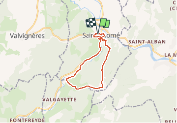
St Thomé 11km

thonyc
User GUIDE

Length
11.3 km

Max alt
360 m

Uphill gradient
377 m
Km-Effort
16.4 km

Min alt
103 m

Downhill gradient
382 m
Boucle
Yes
Creation date :
2021-01-07 12:46:56.713
Updated on :
2021-01-07 16:53:24.774
2h48
Difficulty : Medium

FREE GPS app for hiking
 SityTrail
IGN / Geographical institutes
SityTrail Plus
The world is yours!
About
Trail Walking of 11.3 km to be discovered at Auvergne-Rhône-Alpes, Ardèche, Saint-Thomé. This trail is proposed by thonyc.
Photos


Positioning
Country:
France
Region :
Auvergne-Rhône-Alpes
Department/Province :
Ardèche
Municipality :
Saint-Thomé
Location:
Unknown
Start:(Dec)
Start:(UTM)
629109 ; 4928794 (31T) N.
Comments