


Rully Le GR 76 page 97

grasgilbert
User
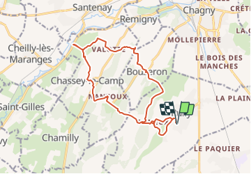

Length
16.3 km

Max alt
365 m

Uphill gradient
623 m
Km-Effort
25 km

Min alt
226 m

Downhill gradient
623 m
Boucle
Yes
Creation date :
2021-01-07 16:28:45.548
Updated on :
2021-08-05 15:09:10.992
4h00
Difficulty : Easy

FREE GPS app for hiking
 SityTrail
IGN / Geographical institutes
SityTrail Plus
The world is yours!
About
Trail On foot of 16.3 km to be discovered at Bourgogne-Franche-Comté, Saône-et-Loire, Rully. This trail is proposed by grasgilbert.
Positioning
Country:
France
Region :
Bourgogne-Franche-Comté
Department/Province :
Saône-et-Loire
Municipality :
Rully
Location:
Unknown
Start:(Dec)
Start:(UTM)
632717 ; 5192402 (31T) N.
Comments
bien