


autour du Valz

jpfrobert
User
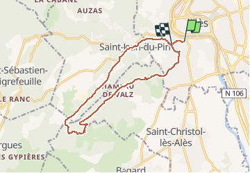

Length
14.9 km

Max alt
340 m

Uphill gradient
357 m
Km-Effort
19.6 km

Min alt
146 m

Downhill gradient
338 m
Boucle
No
Creation date :
2021-01-08 11:03:24.006
Updated on :
2021-01-08 11:14:30.542
3h16
Difficulty : Difficult

FREE GPS app for hiking
 SityTrail
IGN / Geographical institutes
SityTrail Plus
The world is yours!
About
Trail Walking of 14.9 km to be discovered at Occitania, Gard, Alès. This trail is proposed by jpfrobert.
Positioning
Country:
France
Region :
Occitania
Department/Province :
Gard
Municipality :
Alès
Location:
Unknown
Start:(Dec)
Start:(UTM)
586287 ; 4885579 (31T) N.
Comments