


fdu

m@nu
User
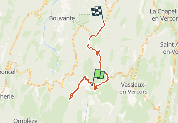

Length
29 km

Max alt
1667 m

Uphill gradient
772 m
Km-Effort
41 km

Min alt
1068 m

Downhill gradient
1276 m
Boucle
No
Creation date :
2021-01-08 10:16:27.283
Updated on :
2021-01-08 15:25:20.683
5h03
Difficulty : Very easy

FREE GPS app for hiking
 SityTrail
IGN / Geographical institutes
SityTrail Plus
The world is yours!
About
Trail Touring skiing of 29 km to be discovered at Auvergne-Rhône-Alpes, Drôme, Bouvante. This trail is proposed by m@nu.
Positioning
Country:
France
Region :
Auvergne-Rhône-Alpes
Department/Province :
Drôme
Municipality :
Bouvante
Location:
Unknown
Start:(Dec)
Start:(UTM)
682665 ; 4974225 (31T) N.
Comments