


2021-01 Rando Forêt Saint-Hubert

rando1490
User
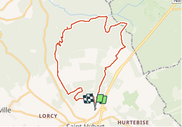

Length
17.3 km

Max alt
583 m

Uphill gradient
436 m
Km-Effort
23 km

Min alt
408 m

Downhill gradient
432 m
Boucle
Yes
Creation date :
2021-01-09 08:57:04.531
Updated on :
2021-04-19 19:36:19.245
3h57
Difficulty : Medium

FREE GPS app for hiking
 SityTrail
IGN / Geographical institutes
SityTrail Plus
The world is yours!
About
Trail Walking of 17.3 km to be discovered at Wallonia, Luxembourg, Saint-Hubert. This trail is proposed by rando1490.
Description
Rando covi-19 à 4 avec en partie de la neige
Positioning
Country:
Belgium
Region :
Wallonia
Department/Province :
Luxembourg
Municipality :
Saint-Hubert
Location:
Saint-Hubert
Start:(Dec)
Start:(UTM)
670482 ; 5544934 (31U) N.
Comments