


ugny

jojo02
User
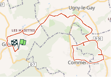

Length
16.6 km

Max alt
134 m

Uphill gradient
243 m
Km-Effort
19.8 km

Min alt
89 m

Downhill gradient
242 m
Boucle
Yes
Creation date :
2021-01-09 13:50:48.717
Updated on :
2021-01-09 15:54:43.08
2h03
Difficulty : Easy

FREE GPS app for hiking
 SityTrail
IGN / Geographical institutes
SityTrail Plus
The world is yours!
About
Trail Mountain bike of 16.6 km to be discovered at Hauts-de-France, Aisne, Guivry. This trail is proposed by jojo02.
Positioning
Country:
France
Region :
Hauts-de-France
Department/Province :
Aisne
Municipality :
Guivry
Location:
Unknown
Start:(Dec)
Start:(UTM)
509065 ; 5499221 (31U) N.
Comments