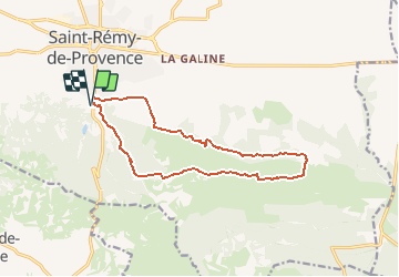
Plateau de Caume

MarcLEBARON
User


4h20
Difficulty : Difficult

FREE GPS app for hiking
 SityTrail
IGN / Geographical institutes
SityTrail Plus
The world is yours!
About
Trail Walking of 14.3 km to be discovered at Provence-Alpes-Côte d'Azur, Bouches-du-Rhône, Saint-Rémy-de-Provence. This trail is proposed by MarcLEBARON.
Description
Boucle parcours plateau de Caume, minéral et superbes vues.
Le retour par le bas de la face Nord ressemble aux montagnes russes dans la partie terminale (casse jambes en fin de rando), c'est pour cela qu'il y a reprise du GR en fin de rando.
Positioning
Comments