


le huit de Becco

stef789
User GUIDE
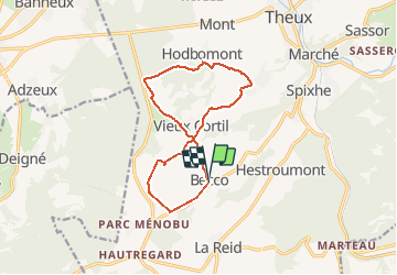

Length
11.6 km

Max alt
359 m

Uphill gradient
273 m
Km-Effort
15.2 km

Min alt
211 m

Downhill gradient
277 m
Boucle
Yes
Creation date :
2021-01-10 09:18:43.245
Updated on :
2021-01-10 14:05:43.947
4h46
Difficulty : Very easy

FREE GPS app for hiking
 SityTrail
IGN / Geographical institutes
SityTrail Plus
The world is yours!
About
Trail Walking of 11.6 km to be discovered at Wallonia, Liège, Theux. This trail is proposed by stef789.
Photos


Positioning
Country:
Belgium
Region :
Wallonia
Department/Province :
Liège
Municipality :
Theux
Location:
La Reid
Start:(Dec)
Start:(UTM)
697700 ; 5598273 (31U) N.
Comments