


Col du Rousset

raygautier
User
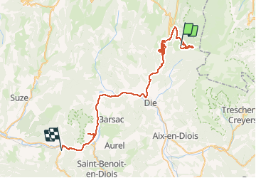

Length
56 km

Max alt
1704 m

Uphill gradient
875 m
Km-Effort
72 km

Min alt
264 m

Downhill gradient
2111 m
Boucle
No
Creation date :
2021-01-10 09:31:44.0
Updated on :
2021-01-10 20:17:11.148
10h42
Difficulty : Unknown

FREE GPS app for hiking
 SityTrail
IGN / Geographical institutes
SityTrail Plus
The world is yours!
About
Trail Walking of 56 km to be discovered at Auvergne-Rhône-Alpes, Drôme, Saint-Agnan-en-Vercors. This trail is proposed by raygautier.
Positioning
Country:
France
Region :
Auvergne-Rhône-Alpes
Department/Province :
Drôme
Municipality :
Saint-Agnan-en-Vercors
Location:
Unknown
Start:(Dec)
Start:(UTM)
691831 ; 4967148 (31T) N.
Comments