


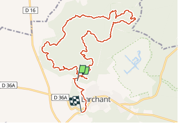
Larchant

sebastienu
User

Length
12.4 km

Max alt
120 m

Uphill gradient
229 m
Km-Effort
15.5 km

Min alt
68 m

Downhill gradient
235 m
Boucle
No
Creation date :
2021-01-09 12:55:09.266
Updated on :
2021-01-10 22:38:19.857
3h08
Difficulty : Very easy

FREE GPS app for hiking
 SityTrail
IGN / Geographical institutes
SityTrail Plus
The world is yours!
About
Trail Walking of 12.4 km to be discovered at Ile-de-France, Seine-et-Marne, Larchant. This trail is proposed by sebastienu.
Description
petite boucle en passant par la fontaine st Mathurin et l'éléphant
Positioning
Country:
France
Region :
Ile-de-France
Department/Province :
Seine-et-Marne
Municipality :
Larchant
Location:
Unknown
Start:(Dec)
Start:(UTM)
469563 ; 5348452 (31U) N.
Comments