


croix

CABERMAT
User
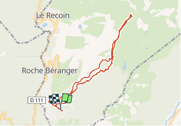

Length
8.7 km

Max alt
2250 m

Uphill gradient
520 m
Km-Effort
15.7 km

Min alt
1726 m

Downhill gradient
532 m
Boucle
Yes
Creation date :
2021-01-11 10:02:40.228
Updated on :
2021-01-11 13:36:16.238
1h55
Difficulty : Very easy

FREE GPS app for hiking
 SityTrail
IGN / Geographical institutes
SityTrail Plus
The world is yours!
About
Trail Walking of 8.7 km to be discovered at Auvergne-Rhône-Alpes, Isère, Chamrousse. This trail is proposed by CABERMAT.
Positioning
Country:
France
Region :
Auvergne-Rhône-Alpes
Department/Province :
Isère
Municipality :
Chamrousse
Location:
Unknown
Start:(Dec)
Start:(UTM)
726540 ; 4998478 (31T) N.
Comments