


randonnée cavali

olivier26
User

Length
12 km

Max alt
889 m

Uphill gradient
589 m
Km-Effort
19.9 km

Min alt
366 m

Downhill gradient
591 m
Boucle
Yes
Creation date :
2014-12-10 00:00:00.0
Updated on :
2014-12-10 00:00:00.0
3h43
Difficulty : Medium

FREE GPS app for hiking
 SityTrail
IGN / Geographical institutes
SityTrail Plus
The world is yours!
About
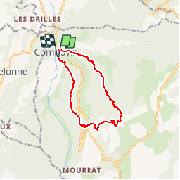
Trail Walking of 12 km to be discovered at Auvergne-Rhône-Alpes, Drôme, Combovin. This trail is proposed by olivier26.
Description
combovin montée Jérôme cavali
Positioning
Country:
France
Region :
Auvergne-Rhône-Alpes
Department/Province :
Drôme
Municipality :
Combovin
Location:
Unknown
Start:(Dec)
Start:(UTM)
664162 ; 4970988 (31T) N.
Comments