


autour de bagard

jpfrobert
User
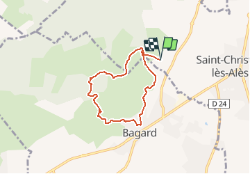

Length
6.4 km

Max alt
284 m

Uphill gradient
194 m
Km-Effort
9 km

Min alt
155 m

Downhill gradient
196 m
Boucle
Yes
Creation date :
2021-01-14 09:34:36.501
Updated on :
2021-01-14 09:35:16.123
1h54
Difficulty : Medium

FREE GPS app for hiking
 SityTrail
IGN / Geographical institutes
SityTrail Plus
The world is yours!
About
Trail Walking of 6.4 km to be discovered at Occitania, Gard, Saint-Christol-lez-Alès. This trail is proposed by jpfrobert.
Positioning
Country:
France
Region :
Occitania
Department/Province :
Gard
Municipality :
Saint-Christol-lez-Alès
Location:
Unknown
Start:(Dec)
Start:(UTM)
584623 ; 4881901 (31T) N.
Comments