


source de Meine

mannequ1
User
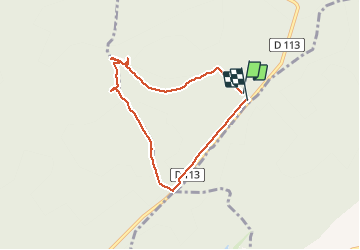

Length
6.1 km

Max alt
432 m

Uphill gradient
88 m
Km-Effort
7.3 km

Min alt
348 m

Downhill gradient
84 m
Boucle
Yes
Creation date :
2014-12-10 00:00:00.0
Updated on :
2014-12-10 00:00:00.0
1h35
Difficulty : Easy

FREE GPS app for hiking
 SityTrail
IGN / Geographical institutes
SityTrail Plus
The world is yours!
About
Trail Walking of 6.1 km to be discovered at Grand Est, Meurthe-et-Moselle, Blénod-lès-Toul. This trail is proposed by mannequ1.
Positioning
Country:
France
Region :
Grand Est
Department/Province :
Meurthe-et-Moselle
Municipality :
Blénod-lès-Toul
Location:
Unknown
Start:(Dec)
Start:(UTM)
708191 ; 5384432 (31U) N.
Comments