


côte de meuse et vallée maxey sur vaise

mannequ1
User
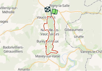

Length
21 km

Max alt
316 m

Uphill gradient
223 m
Km-Effort
24 km

Min alt
242 m

Downhill gradient
217 m
Boucle
No
Creation date :
2014-12-10 00:00:00.0
Updated on :
2014-12-10 00:00:00.0
5h11
Difficulty : Easy

FREE GPS app for hiking
 SityTrail
IGN / Geographical institutes
SityTrail Plus
The world is yours!
About
Trail Walking of 21 km to be discovered at Grand Est, Meuse, Vaucouleurs. This trail is proposed by mannequ1.
Positioning
Country:
France
Region :
Grand Est
Department/Province :
Meuse
Municipality :
Vaucouleurs
Location:
Unknown
Start:(Dec)
Start:(UTM)
697402 ; 5386471 (31U) N.
Comments