


Mesnil. st Amand

papiou
User
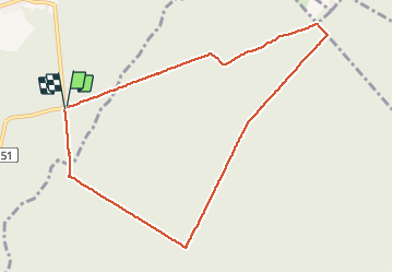


1h28
Difficulty : Easy

FREE GPS app for hiking
 SityTrail
IGN / Geographical institutes
SityTrail Plus
The world is yours!
About
Trail Walking of 8.5 km to be discovered at Hauts-de-France, Nord, Saint-Amand-les-Eaux. This trail is proposed by papiou.
Description
rdv parking carrefour Mesnil (interrogé allée des hêtres-dreve de raismes) puis prendre dreve petit bouze pour rejoindre MF de suchemont puis coucou et revenir par dreve Notre dame en passant par étoiles suchemont et Cernay pour finir BB rose
Photos


Positioning
Comments