


Au dessus de Cahors 21 lm

fxhedon
User
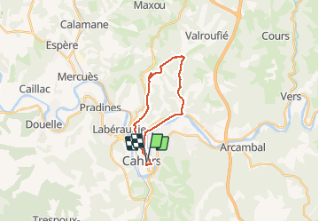

Length
21 km

Max alt
298 m

Uphill gradient
357 m
Km-Effort
26 km

Min alt
115 m

Downhill gradient
357 m
Boucle
Yes
Creation date :
2021-01-19 13:28:32.0
Updated on :
2021-01-19 15:38:02.618
2h07
Difficulty : Unknown

FREE GPS app for hiking
 SityTrail
IGN / Geographical institutes
SityTrail Plus
The world is yours!
About
Trail Mountain bike of 21 km to be discovered at Occitania, Lot, Cahors. This trail is proposed by fxhedon.
Positioning
Country:
France
Region :
Occitania
Department/Province :
Lot
Municipality :
Cahors
Location:
Unknown
Start:(Dec)
Start:(UTM)
375944 ; 4922950 (31T) N.
Comments