


supeyres

m@nu
User
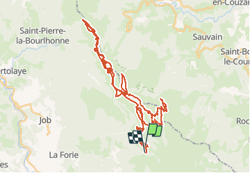

Length
68 km

Max alt
1621 m

Uphill gradient
1905 m
Km-Effort
94 km

Min alt
1347 m

Downhill gradient
1953 m
Boucle
No
Creation date :
2021-01-19 10:57:54.893
Updated on :
2021-01-20 07:30:39.735
5h04
Difficulty : Very easy

FREE GPS app for hiking
 SityTrail
IGN / Geographical institutes
SityTrail Plus
The world is yours!
About
Trail Touring skiing of 68 km to be discovered at Auvergne-Rhône-Alpes, Puy-de-Dôme, Valcivières. This trail is proposed by m@nu.
Positioning
Country:
France
Region :
Auvergne-Rhône-Alpes
Department/Province :
Puy-de-Dôme
Municipality :
Valcivières
Location:
Unknown
Start:(Dec)
Start:(UTM)
565874 ; 5049670 (31T) N.
Comments