


Le grand echaillon

philou68
User
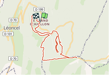

Length
10.9 km

Max alt
1404 m

Uphill gradient
357 m
Km-Effort
15.6 km

Min alt
1157 m

Downhill gradient
353 m
Boucle
Yes
Creation date :
2021-01-20 09:08:17.757
Updated on :
2021-01-20 13:29:57.444
4h09
Difficulty : Very easy

FREE GPS app for hiking
 SityTrail
IGN / Geographical institutes
SityTrail Plus
The world is yours!
About
Trail Walking of 10.9 km to be discovered at Auvergne-Rhône-Alpes, Drôme, Léoncel. This trail is proposed by philou68.
Description
Raquettes
Positioning
Country:
France
Region :
Auvergne-Rhône-Alpes
Department/Province :
Drôme
Municipality :
Léoncel
Location:
Unknown
Start:(Dec)
Start:(UTM)
674353 ; 4975720 (31T) N.
Comments