


Corençon - chateau julien

maupassant38
User
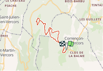

Length
15.5 km

Max alt
1550 m

Uphill gradient
470 m
Km-Effort
22 km

Min alt
1147 m

Downhill gradient
471 m
Boucle
Yes
Creation date :
2021-01-20 09:51:54.535
Updated on :
2021-01-20 15:09:04.829
2h09
Difficulty : Medium

FREE GPS app for hiking
 SityTrail
IGN / Geographical institutes
SityTrail Plus
The world is yours!
About
Trail Cross-country skiing of 15.5 km to be discovered at Auvergne-Rhône-Alpes, Isère, Corrençon-en-Vercors. This trail is proposed by maupassant38.
Positioning
Country:
France
Region :
Auvergne-Rhône-Alpes
Department/Province :
Isère
Municipality :
Corrençon-en-Vercors
Location:
Unknown
Start:(Dec)
Start:(UTM)
698389 ; 4988695 (31T) N.
Comments