


200121

Nila81
User
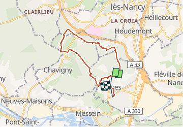

Length
12.7 km

Max alt
423 m

Uphill gradient
195 m
Km-Effort
15.3 km

Min alt
282 m

Downhill gradient
215 m
Boucle
No
Creation date :
2021-01-20 12:29:25.158
Updated on :
2021-01-20 15:50:36.288
3h19
Difficulty : Very easy

FREE GPS app for hiking
 SityTrail
IGN / Geographical institutes
SityTrail Plus
The world is yours!
About
Trail Walking of 12.7 km to be discovered at Grand Est, Meurthe-et-Moselle, Ludres. This trail is proposed by Nila81.
Description
petit tour plateau
Positioning
Country:
France
Region :
Grand Est
Department/Province :
Meurthe-et-Moselle
Municipality :
Ludres
Location:
Unknown
Start:(Dec)
Start:(UTM)
290770 ; 5389431 (32U) N.
Comments