


SityTrail - 1110728 - but-de-nevex-raquettes

thonyc
User GUIDE
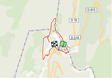

Length
7.1 km

Max alt
1641 m

Uphill gradient
406 m
Km-Effort
12.5 km

Min alt
1235 m

Downhill gradient
409 m
Boucle
Yes
Creation date :
2021-01-21 08:57:07.866
Updated on :
2021-02-17 08:36:00.398
3h59
Difficulty : Difficult
--
Difficulty : Difficult

FREE GPS app for hiking
 SityTrail
IGN / Geographical institutes
SityTrail Plus
The world is yours!
About
Trail Walking of 7.1 km to be discovered at Auvergne-Rhône-Alpes, Drôme, Chamaloc. This trail is proposed by thonyc.
Description
14/02/2019 départ sud du tunnel du Rousset la traversée du pierrier au départ est délicate
Positioning
Country:
France
Region :
Auvergne-Rhône-Alpes
Department/Province :
Drôme
Municipality :
Chamaloc
Location:
Unknown
Start:(Dec)
Start:(UTM)
689392 ; 4967769 (31T) N.
Comments