24/01/21- Cascade Nideck et château par la M.F

delm
User
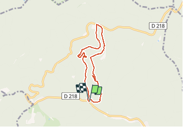

Length
6.1 km

Max alt
619 m

Uphill gradient
288 m
Km-Effort
9.9 km

Min alt
347 m

Downhill gradient
286 m
Boucle
Yes
Creation date :
2021-01-23 09:26:50.585
Updated on :
2021-01-24 17:15:34.157
--
Difficulty : Very easy

FREE GPS app for hiking
 SityTrail
IGN / Geographical institutes
SityTrail Plus
The world is yours!
About
Trail On foot of 6.1 km to be discovered at Grand Est, Bas-Rhin, Oberhaslach. This trail is proposed by delm.
Description
Randonnée agréable et sympathique
Quelques petites montées raide au départ.
Facile -moyen
6,870 Km
Effectuée en 2 h 30
Positioning
Country:
France
Region :
Grand Est
Department/Province :
Bas-Rhin
Municipality :
Oberhaslach
Location:
Unknown
Start:(Dec)
Start:(UTM)
373587 ; 5380988 (32U) N.
Comments