


Monteleger

raygautier
User
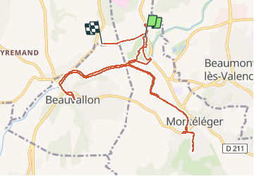

Length
12.8 km

Max alt
156 m

Uphill gradient
115 m
Km-Effort
14.3 km

Min alt
117 m

Downhill gradient
117 m
Boucle
No
Creation date :
2021-01-23 13:54:08.0
Updated on :
2021-01-23 16:52:06.565
2h57
Difficulty : Unknown

FREE GPS app for hiking
 SityTrail
IGN / Geographical institutes
SityTrail Plus
The world is yours!
About
Trail Walking of 12.8 km to be discovered at Auvergne-Rhône-Alpes, Drôme, Montéléger. This trail is proposed by raygautier.
Positioning
Country:
France
Region :
Auvergne-Rhône-Alpes
Department/Province :
Drôme
Municipality :
Montéléger
Location:
Unknown
Start:(Dec)
Start:(UTM)
651743 ; 4970071 (31T) N.
Comments