


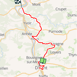
GR 125 Godinne - Dinant

tmenet
User


4h41
Difficulty : Medium

FREE GPS app for hiking
 SityTrail
IGN / Geographical institutes
SityTrail Plus
The world is yours!
About
Trail Walking of 21 km to be discovered at Wallonia, Namur, Dinant. This trail is proposed by tmenet.
Description
Parcours entre Dinant et Godinne. Très belles vues sur la Meuse et sur les hauteurs de Dinant et sa région. Prévoir une lampe de poche pour le passage par la poudrière de Dinant. Il est possible d'éviter la poudrière en partant par la gauche de la collégiale. Il y a un train direct qui part toutes les heures de Godinne pour rejoindre Dinant en 12 minutes. C'est vraiment pratique :)
Positioning
Comments