


Col de Portes & Draille du peyrerol

paull
User
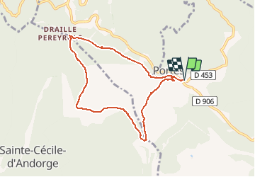

Length
8.2 km

Max alt
623 m

Uphill gradient
141 m
Km-Effort
10.1 km

Min alt
544 m

Downhill gradient
142 m
Boucle
Yes
Creation date :
2021-01-24 08:09:16.382
Updated on :
2021-01-24 09:12:19.294
2h17
Difficulty : Medium

FREE GPS app for hiking
 SityTrail
IGN / Geographical institutes
SityTrail Plus
The world is yours!
About
Trail Walking of 8.2 km to be discovered at Occitania, Gard, Portes. This trail is proposed by paull.
Positioning
Country:
France
Region :
Occitania
Department/Province :
Gard
Municipality :
Portes
Location:
Unknown
Start:(Dec)
Start:(UTM)
581813 ; 4902233 (31T) N.
Comments