


coucy

jojo02
User
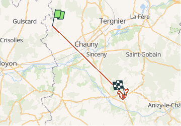

Length
34 km

Max alt
191 m

Uphill gradient
533 m
Km-Effort
41 km

Min alt
36 m

Downhill gradient
535 m
Boucle
No
Creation date :
2021-01-23 08:48:10.663
Updated on :
2021-01-24 10:27:31.28
1h55
Difficulty : Very easy

FREE GPS app for hiking
 SityTrail
IGN / Geographical institutes
SityTrail Plus
The world is yours!
About
Trail Trail of 34 km to be discovered at Hauts-de-France, Aisne, Guivry. This trail is proposed by jojo02.
Positioning
Country:
France
Region :
Hauts-de-France
Department/Province :
Aisne
Municipality :
Guivry
Location:
Unknown
Start:(Dec)
Start:(UTM)
509102 ; 5499217 (31U) N.
Comments