


pointe du col

franquen
User

Length
12.4 km

Max alt
2175 m

Uphill gradient
995 m
Km-Effort
26 km

Min alt
1178 m

Downhill gradient
985 m
Boucle
Yes
Creation date :
2021-01-24 08:04:50.334
Updated on :
2021-01-24 15:25:58.523
5h17
Difficulty : Very easy

FREE GPS app for hiking
 SityTrail
IGN / Geographical institutes
SityTrail Plus
The world is yours!
About
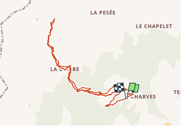
Trail Touring skiing of 12.4 km to be discovered at Auvergne-Rhône-Alpes, Savoy, Aime-la-Plagne. This trail is proposed by franquen.
Positioning
Country:
France
Region :
Auvergne-Rhône-Alpes
Department/Province :
Savoy
Municipality :
Aime-la-Plagne
Location:
Aime
Start:(Dec)
Start:(UTM)
313155 ; 5047552 (32T) N.
Comments