


antecime de Sangraure

trailer.nono
User
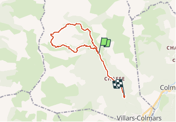

Length
13 km

Max alt
2415 m

Uphill gradient
884 m
Km-Effort
26 km

Min alt
1314 m

Downhill gradient
1110 m
Boucle
No
Creation date :
2021-01-24 09:18:34.652
Updated on :
2021-01-24 18:14:00.637
3h14
Difficulty : Very easy

FREE GPS app for hiking
 SityTrail
IGN / Geographical institutes
SityTrail Plus
The world is yours!
About
Trail Touring skiing of 13 km to be discovered at Provence-Alpes-Côte d'Azur, Alpes-de-Haute-Provence, Villars-Colmars. This trail is proposed by trailer.nono.
Positioning
Country:
France
Region :
Provence-Alpes-Côte d'Azur
Department/Province :
Alpes-de-Haute-Provence
Municipality :
Villars-Colmars
Location:
Unknown
Start:(Dec)
Start:(UTM)
306256 ; 4896780 (32T) N.
Comments