


circuit des tunnels

mannequ1
User
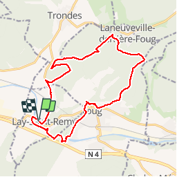

Length
16.6 km

Max alt
382 m

Uphill gradient
383 m
Km-Effort
22 km

Min alt
244 m

Downhill gradient
381 m
Boucle
Yes
Creation date :
2014-12-10 00:00:00.0
Updated on :
2014-12-10 00:00:00.0
4h39
Difficulty : Medium

FREE GPS app for hiking
 SityTrail
IGN / Geographical institutes
SityTrail Plus
The world is yours!
About
Trail Walking of 16.6 km to be discovered at Grand Est, Meurthe-et-Moselle, Lay-Saint-Remy. This trail is proposed by mannequ1.
Description
circuit proposé par l'association sentiers de la linotte
Positioning
Country:
France
Region :
Grand Est
Department/Province :
Meurthe-et-Moselle
Municipality :
Lay-Saint-Remy
Location:
Unknown
Start:(Dec)
Start:(UTM)
703156 ; 5395714 (31U) N.
Comments