Trail Walking Taillet - Taillet N D de Roure - Photo
© OpenStreetMap contributors
Length
Length
14.4 km
Max alt
Max alt
645 m
Uphill gradient
Uphill gradient
415 m
Km-Effort
Km-Effort  
20 km
Min alt
Min alt
384 m
Downhill gradient
Downhill gradient
415 m
Boucle
Boucle
Yes
Creation date :
2021-01-26 09:40:26.339
Updated on :
2021-01-26 14:40:00.477

(1 Reviews)

Walking
Walking
4h58
Difficulty : Medium

Scan this QR Code to open this trail in the SityTrail application

FREE GPS app for hiking

Logo SityTrail SityTrail

IGN / Geographical institutes

Download SityTrail from the App Store Download SityTrail from Google Play

Logo SityTrail SityTrail World

The world is yours!

Download SityTrail from the App Store Download SityTrail from Google Play Download SityTrail on Huawei AppGallery

About

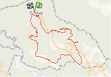
Trail Walking of 14.4 km to be discovered at Occitania, Pyrénées-Orientales, Taillet. This trail is proposed by zenyves66.

Description

moyen

Elevation profile

Positioning

Country:
France
Region :
Occitania
Department/Province :
Pyrénées-Orientales
Municipality :
Taillet
Location:
Unknown
Start:(UTM)
473035 ; 4708310 (31T) N.

Comments

Please log in to post a review or rate the element


belle randonnée mais un petit peu trop de route goudronnée


Trails nearby

Trail Walking Llauro - Col de Llauro- Roc del Quers - Photo
Walking
perittel

Walking

Easy
(1)
Llauro, Occitania, Pyrénées-Orientales, France
8.9 km | 12.9 km-effort
3h 11min
Yes
Trail Walking Montbolo - Montbolo: du col dela reducta au col de Formentera - Photo
Walking
robertperello

Walking

Medium
Montbolo, Occitania, Pyrénées-Orientales, France
11.9 km | 17 km-effort
3h 4min
Yes
Trail Walking Reynès - taillet ( vallespir ) - Photo
Walking
gogo1965

Walking

Medium
Reynès, Occitania, Pyrénées-Orientales, France
6.3 km | 9.4 km-effort
2h 8min
Yes
Trail Walking Amélie-les-Bains-Palalda - Amélie les Bains - Roc de la Campana - Photo
Walking
MarieFrancoise

Walking

Very difficult
Amélie-les-Bains-Palalda, Occitania, Pyrénées-Orientales, France
13.5 km | 22 km-effort
6h 16min
Yes
Trail Walking Oms - Ils - Photo
Walking
ombrabella

Walking

Oms, Occitania, Pyrénées-Orientales, France
11.9 km | 16.9 km-effort
3h 2min
Yes
Trail Walking Reynès - Le Vila - La Serra de Taillet - Photo
Walking
patbt

Walking

Medium
(1)
Reynès, Occitania, Pyrénées-Orientales, France
16.1 km | 24 km-effort
4h 6min
Yes
Trail Walking Reynès - Chapelle du Route - Photo
Walking
ombrabella

Walking

Very easy
Reynès, Occitania, Pyrénées-Orientales, France
10.1 km | 14.8 km-effort
2h 50min
No
Trail Walking Reynès - Reynes Carrieres Talc_T - Photo
Walking
force

Walking

Medium
Reynès, Occitania, Pyrénées-Orientales, France
12.6 km | 20 km-effort
4h 26min
Yes
Trail Walking Reynès - PONT DE REYNES 66 - chemin des mas - REYNES - le Vallespir - Photo
Walking
jeff66

Walking

Medium
Reynès, Occitania, Pyrénées-Orientales, France
12.3 km | 17.4 km-effort
2h 13min
Yes


Close
My subscriptions