


sortie du d'aujourd'hui

choumac08
User
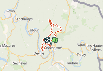

Length
21 km

Max alt
426 m

Uphill gradient
979 m
Km-Effort
34 km

Min alt
132 m

Downhill gradient
979 m
Boucle
Yes
Creation date :
2021-01-27 20:06:57.963
Updated on :
2021-01-30 05:22:10.872
--
Difficulty : Very easy

FREE GPS app for hiking
 SityTrail
IGN / Geographical institutes
SityTrail Plus
The world is yours!
About
Trail Trail of 21 km to be discovered at Grand Est, Ardennes, Monthermé. This trail is proposed by choumac08.
Positioning
Country:
France
Region :
Grand Est
Department/Province :
Ardennes
Municipality :
Monthermé
Location:
Unknown
Start:(Dec)
Start:(UTM)
624642 ; 5527474 (31U) N.
Comments