


le tas de fumier 1

SUPERMAMINOU2004
User
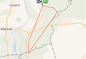

Length
6.4 km

Max alt
128 m

Uphill gradient
153 m
Km-Effort
8.4 km

Min alt
58 m

Downhill gradient
154 m
Boucle
Yes
Creation date :
2021-01-28 08:27:03.718
Updated on :
2021-01-28 11:15:35.835
2h48
Difficulty : Very easy

FREE GPS app for hiking
 SityTrail
IGN / Geographical institutes
SityTrail Plus
The world is yours!
About
Trail Walking of 6.4 km to be discovered at Ile-de-France, Essonne, Maisse. This trail is proposed by SUPERMAMINOU2004.
Positioning
Country:
France
Region :
Ile-de-France
Department/Province :
Essonne
Municipality :
Maisse
Location:
Unknown
Start:(Dec)
Start:(UTM)
455704 ; 5361527 (31U) N.
Comments
la rando faisait en réalité 11.5 il manque une partie du trajet