Trail Walking Ponlat-Taillebourg - chapelle st jean ponlat - Photo
 martoche
martoche

User

© OpenStreetMap contributors
Length
Length
6.5 km
Max alt
Max alt
530 m
Uphill gradient
Uphill gradient
111 m
Km-Effort
Km-Effort  
7.9 km
Min alt
Min alt
448 m
Downhill gradient
Downhill gradient
112 m
Boucle
Boucle
Yes
Creation date :
2021-01-28 12:51:13.749
Updated on :
2021-01-28 14:39:46.352

(0 Reviews)

Walking
Walking
1h47
Difficulty : Easy

Scan this QR Code to open this trail in the SityTrail application

FREE GPS app for hiking

Logo SityTrail SityTrail

IGN / Geographical institutes

Download SityTrail from the App Store Download SityTrail from Google Play

Logo SityTrail SityTrail World

The world is yours!

Download SityTrail from the App Store Download SityTrail from Google Play Download SityTrail on Huawei AppGallery

About

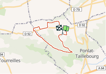
Trail Walking of 6.5 km to be discovered at Occitania, Haute-Garonne, Ponlat-Taillebourg. This trail is proposed by martoche.

Description

boucle a travers  champs sur piste  oueuse par temps humide

Elevation profile

Positioning

Country:
France
Region :
Occitania
Department/Province :
Haute-Garonne
Municipality :
Ponlat-Taillebourg
Location:
Unknown
Start:(UTM)
303626 ; 4777110 (31T) N.

Trails nearby

Trail Walking Martres-de-Rivière - cap de  Rouzet en boucle depuis Martres de rivière  - Photo
Walking
GUIDE
lhomme.ph

Walking

Easy
Martres-de-Rivière, Occitania, Haute-Garonne, France
11 km | 16.2 km-effort
3h 18min
Yes
Trail sport Bordes-de-Rivière - 2021-10-31_09h01m59_Cirkwi-Bordes_de_Rivière_Plaine__Les_canaux_d_irrigation_ - Photo
sport
jojo1412

sport

Very easy
Bordes-de-Rivière, Occitania, Haute-Garonne, France
3.6 km | 3.9 km-effort
Unknown
Yes
Trail Walking Martres-de-Rivière - cap de houcheton depuis Martres de rivière  - Photo
Walking
GUIDE
lhomme.ph

Walking

Very easy
Martres-de-Rivière, Occitania, Haute-Garonne, France
6.8 km | 10 km-effort
3h 28min
No
Trail Walking Clarac - Clarac, evelyne - Photo
Walking
Jeanne Pene

Walking

Very easy
Clarac, Occitania, Haute-Garonne, France
8.5 km | 10.7 km-effort
2h 13min
No
Trail Running Montréjeau - Montrejeau - Photo
Running
skwick

Running

Easy
Montréjeau, Occitania, Haute-Garonne, France
14.8 km | 18.7 km-effort
1h 54min
No
Trail Walking Clarac - cier avec evlyne nouveau chemin - Photo
Walking
Jeanne Pene

Walking

Very easy
Clarac, Occitania, Haute-Garonne, France
63 km | 77 km-effort
28h 21min
No
Trail Walking Clarac - pic - Photo
Walking
Jeanne Pene

Walking

Very difficult
Clarac, Occitania, Haute-Garonne, France
77 km | 100 km-effort
12h 24min
No
Trail Walking Clarac - hourquette - Photo
Walking
Jeanne Pene

Walking

Very difficult
Clarac, Occitania, Haute-Garonne, France
72 km | 91 km-effort
2h 6min
No
Trail Walking Clarac - ouderou - Photo
Walking
Jeanne Pene

Walking

Very difficult
Clarac, Occitania, Haute-Garonne, France
91 km | 105 km-effort
67h 54min
No


Close
My subscriptions