


congis-crouy

Bernardcom
User
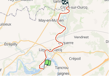

Length
19 km

Max alt
79 m

Uphill gradient
159 m
Km-Effort
21 km

Min alt
47 m

Downhill gradient
163 m
Boucle
No
Creation date :
2021-01-29 08:42:24.207
Updated on :
2021-01-29 14:16:13.021
4h58
Difficulty : Very easy

FREE GPS app for hiking
 SityTrail
IGN / Geographical institutes
SityTrail Plus
The world is yours!
About
Trail Walking of 19 km to be discovered at Ile-de-France, Seine-et-Marne, Isles-les-Meldeuses. This trail is proposed by Bernardcom.
Positioning
Country:
France
Region :
Ile-de-France
Department/Province :
Seine-et-Marne
Municipality :
Isles-les-Meldeuses
Location:
Unknown
Start:(Dec)
Start:(UTM)
500530 ; 5427250 (31U) N.
Comments