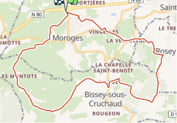
Moroges Le Mont Brogny page 43

grasgilbert
User

Length
12.8 km

Max alt
448 m

Uphill gradient
337 m
Km-Effort
17.3 km

Min alt
237 m

Downhill gradient
337 m
Boucle
Yes
Creation date :
2021-01-29 11:48:07.953
Updated on :
2025-01-28 15:12:04.727
3h55
Difficulty : Difficult

FREE GPS app for hiking
 SityTrail
IGN / Geographical institutes
SityTrail Plus
The world is yours!
About
Trail Walking of 12.8 km to be discovered at Bourgogne-Franche-Comté, Saône-et-Loire, Moroges. This trail is proposed by grasgilbert.
Positioning
Country:
France
Region :
Bourgogne-Franche-Comté
Department/Province :
Saône-et-Loire
Municipality :
Moroges
Location:
Unknown
Start:(Dec)
Start:(UTM)
627600 ; 5179080 (31T) N.
Comments