


2021-01-29_17h19m09_Saint-Étienne de fontbellon ah la la la la

raab
User
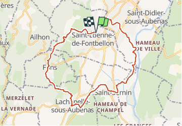

Length
18.8 km

Max alt
341 m

Uphill gradient
311 m
Km-Effort
23 km

Min alt
160 m

Downhill gradient
311 m
Boucle
Yes
Creation date :
2021-01-29 16:19:10.314
Updated on :
2021-01-29 16:19:11.555

FREE GPS app for hiking
 SityTrail
IGN / Geographical institutes
SityTrail Plus
The world is yours!
About
Trail of 18.8 km to be discovered at Auvergne-Rhône-Alpes, Ardèche, Saint-Étienne-de-Fontbellon. This trail is proposed by raab.
Positioning
Country:
France
Region :
Auvergne-Rhône-Alpes
Department/Province :
Ardèche
Municipality :
Saint-Étienne-de-Fontbellon
Location:
Unknown
Start:(Dec)
Start:(UTM)
609556 ; 4939412 (31T) N.
Comments