


Ermont-Lac d'enghien

csy95
User
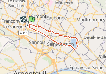

Length
11.6 km

Max alt
62 m

Uphill gradient
68 m
Km-Effort
12.5 km

Min alt
35 m

Downhill gradient
69 m
Boucle
Yes
Creation date :
2021-01-30 13:01:32.752
Updated on :
2021-01-30 13:02:25.963
2h49
Difficulty : Difficult

FREE GPS app for hiking
 SityTrail
IGN / Geographical institutes
SityTrail Plus
The world is yours!
About
Trail Walking of 11.6 km to be discovered at Ile-de-France, Val-d'Oise, Ermont. This trail is proposed by csy95.
Positioning
Country:
France
Region :
Ile-de-France
Department/Province :
Val-d'Oise
Municipality :
Ermont
Location:
Unknown
Start:(Dec)
Start:(UTM)
444847 ; 5425977 (31U) N.
Comments