


Alpe d' Huez Château Noir Isère) CAF

TRIMAILLE
User
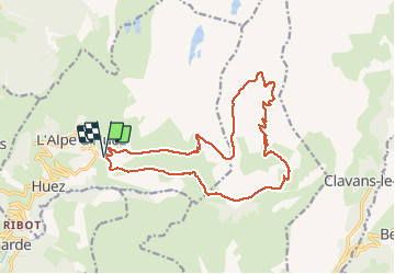

Length
19.4 km

Max alt
2741 m

Uphill gradient
1065 m
Km-Effort
34 km

Min alt
1755 m

Downhill gradient
1064 m
Boucle
Yes
Creation date :
2021-01-30 14:11:19.746
Updated on :
2021-01-30 15:47:14.392
7h38
Difficulty : Very difficult

FREE GPS app for hiking
 SityTrail
IGN / Geographical institutes
SityTrail Plus
The world is yours!
About
Trail Walking of 19.4 km to be discovered at Auvergne-Rhône-Alpes, Isère, Huez. This trail is proposed by TRIMAILLE.
Positioning
Country:
France
Region :
Auvergne-Rhône-Alpes
Department/Province :
Isère
Municipality :
Huez
Location:
Unknown
Start:(Dec)
Start:(UTM)
270032 ; 4996934 (32T) N.
Comments