


pic de la gardiette bagnols en foret

Michel DUBOIS
User
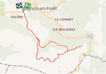

Length
10.1 km

Max alt
352 m

Uphill gradient
258 m
Km-Effort
13.5 km

Min alt
244 m

Downhill gradient
258 m
Boucle
Yes
Creation date :
2021-01-30 18:34:16.266
Updated on :
2021-01-30 18:37:03.655
3h04
Difficulty : Medium

FREE GPS app for hiking
 SityTrail
IGN / Geographical institutes
SityTrail Plus
The world is yours!
About
Trail Walking of 10.1 km to be discovered at Provence-Alpes-Côte d'Azur, Var, Bagnols-en-Forêt. This trail is proposed by Michel DUBOIS.
Description
départ de la chapelle notre dame à bagnols en foret sur la D47
Positioning
Country:
France
Region :
Provence-Alpes-Côte d'Azur
Department/Province :
Var
Municipality :
Bagnols-en-Forêt
Location:
Unknown
Start:(Dec)
Start:(UTM)
313274 ; 4822935 (32T) N.
Comments