


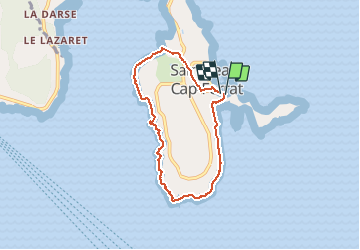
Tour du cap Ferrat

aris
User

Length
6.6 km

Max alt
49 m

Uphill gradient
169 m
Km-Effort
8.8 km

Min alt
0 m

Downhill gradient
172 m
Boucle
Yes
Creation date :
2021-01-31 09:50:00.875
Updated on :
2021-02-13 21:55:03.083
3h26
Difficulty : Very easy

FREE GPS app for hiking
 SityTrail
IGN / Geographical institutes
SityTrail Plus
The world is yours!
About
Trail Walking of 6.6 km to be discovered at Provence-Alpes-Côte d'Azur, Maritime Alps, Saint-Jean-Cap-Ferrat. This trail is proposed by aris.
Description
Balade tranquille au bord de la mer
Positioning
Country:
France
Region :
Provence-Alpes-Côte d'Azur
Department/Province :
Maritime Alps
Municipality :
Saint-Jean-Cap-Ferrat
Location:
Unknown
Start:(Dec)
Start:(UTM)
365886 ; 4838561 (32T) N.
Comments