


joyeuses

raab
User
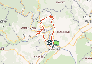

Length
12.3 km

Max alt
382 m

Uphill gradient
356 m
Km-Effort
17 km

Min alt
153 m

Downhill gradient
357 m
Boucle
Yes
Creation date :
2021-01-31 09:17:05.549
Updated on :
2021-02-01 13:31:28.291
6h01
Difficulty : Easy

FREE GPS app for hiking
 SityTrail
IGN / Geographical institutes
SityTrail Plus
The world is yours!
About
Trail Walking of 12.3 km to be discovered at Auvergne-Rhône-Alpes, Ardèche, Joyeuse. This trail is proposed by raab.
Positioning
Country:
France
Region :
Auvergne-Rhône-Alpes
Department/Province :
Ardèche
Municipality :
Joyeuse
Location:
Unknown
Start:(Dec)
Start:(UTM)
598573 ; 4926014 (31T) N.
Comments